Rugged GPS Touchscreen Navigator with inReach Technology
Go Into the Wild with a Satellite Connection
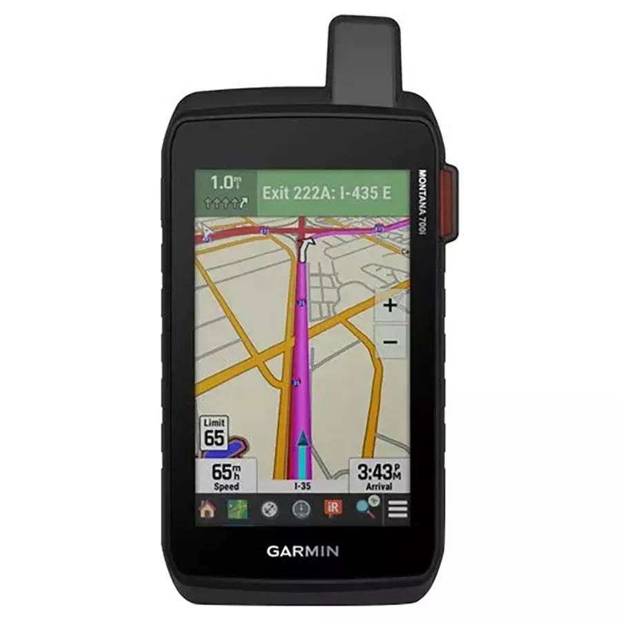
To keep adventurers in touch and on track, the Montana 700i handheld combines the flexibility of on-or off-road navigation with global messaging and interactive SOS via inReach satellite technology
- Big news. A full Qwerty keyboard lets you easily type messages
- Wander wider and still stay in touch-with inReach for messaging and 24/7 SOS
- Routable topographic maps? Check. Now you’re free to take it off-road or on
- Built like a tank. Meets MIL-STD 810 for thermal, shock, water and vibration
- Get the clear perspective of BirdsEye Satellite Imagery right to your device
- Power your adventures with 18+hrs of lithium-ion battery life in GPS mode
Link Up From Way Out-with inReach Technology
- Two-way Messaging: Exchange text messages with loved ones, post to social media or communicate via inReach device to inReach device in the field
- Interactive SOS: In case of emergency, trigger an interactive SOS message to GEOS, the Garmin-powered International Emergency Response Coordination Center (IERCC) with professional 24/7 global monitoring and response center
- Global Connectivity: Instead of relying on cellphone coverage, now your messages, SOS and tracking are transferred via the 100% global Iridium satellite network
- inReach Weather: inReach weather forecast service provides detailed updates directly to your Montana handheld or paired devices, so you’ll know what to expect en route
Be prepared. With Navigation for Any Situation
- Rugged by Design: This durable, water-resistant handheld is tested to U.S. military standards and features a glove-friendly 5″ touchscreen that’s 50% larger than previous Montana models
- City Navigator Maps: Seamlessly transition from trails to road navigation with preloaded City Navigator street mapping, which guides your drive with easy-to-follow turn-by-turn directions
- Topoactive Maps: To navigate your adventures, use preloaded topographical maps for the U.S. and Canada. View terrain contours, elevations, coastlines, rivers, landmarks and more
- Additional Maps: With 16 GB of onboard memory and a microSD card slot for expandable storage, you can download even more maps such as BlueChart g3 for the water
- Public Land Boundaries: Optional display of federal public land boundaries on topographical maps helps you know that you’re venturing where you’re supposed to be
- Satellite Views: Use direct-to-device downloads of BirdsEye Satellite Imagery (no annual subscription required) to see photo-realistic views and create waypoints based on landmarks
- ABC Sensors: Navigate your next trail with ABC sensors, including an altimeter for elevation data, barometer to monitor weather and 3-axis electronic compass
- Active Weather: Use cellular connectivity to access up-to-date Active Weather forecasts through the Garmin Connect app
- Dog Tracking: For hunters and trainers, this Montana syncs with compatible Astro or Alpha series handhelds (sold separately) to help track sporting dogs in the field
- Wikiloc Trails: This preloaded app lets you easily download hiking, cycling and other Wikiloc trails shared by outdoor enthusiasts like you. Get a free 60-day Wikiloc Premium trial to try this and other exclusive features
Stay On Track While Venturing Off-Grid
- Multi-GNSS Support: Access to both GPS and Galileo satellite networks enables Montana 700i to track in more challenging environments than GPS alone
- Tracking: Using your web-based MapShare trip-sharing page, followers can see your progress, ping your device to see your GPS location and exchange messages during your trip
- Expedition Mode: Trek far and wide off-grid. Use Expedition mode, an ultralow-power GPS reference, to keep Montana tracking for a week or more between recharges
- Extended Battery Life: An internal, rechargeable lithium-ion battery pack provides more than 18 hrs of battery life in GPS mode
- Vehicle Mounts: A variety of Montana handheld-compatible mounts (sold separately) lets you adapt your navigator for use on ATVs, boats, cars, motorcycles, RVs or other vehicles
- Garmin Explore App for off-grid navigation and more
- Communicate globally with inReach satellite technology
In the Box
- Montana 700i
- Lithium-ion battery pack
- USB cable
- Documentation
Specifications
- Dimension: 3.6″ x 7.2″ x 1.3″
- Touchscreen: Yes
- Display Size: 2.55″ W x 4.25″ H; 5″ diag
- Display Resolution: 480 x 800 pixels
- Display Type: WVGA Transflective, Dual Orientation
- Weight: 14.5 oz with included lithium-ion battery pack
- Battery Type: Rechargeable Lithium-Ion (included)
- Battery Life: GPS Mode: up to 18 hrs GPS Mode, 10 min Tracking: up to 18 hrs Expedition Mode: up to 330 hrs Expedition Mode, 30 min Tracking: up to 300 hrs
- Waterproof: IPX7
- MIL-STD-810: Yes (Thermal, Shock, Water, Vibe)
- Interface: High Speed Micro USB and NMEA 0183 Compatible
- Memory/History: 16 GB (user space varies based on included mapping)
Maps & Memory
- Preloaded Maps: Yes (TopoActive, by Region; City Navigator Maps, North America; Federal Public Lands Map, US only)
- Ability to Add Maps: Yes
- Basemap: Yes
- Automatic Routing (Turn by Turn Routing on Roads) for Outdoor Activities: Yes
- Automatic Routing (Turn by Turn Routing on Roads) for Motorized Vehicles: Yes
- Map Segments: 15000
- BirdsEye: Yes (Direct to Device)
- Includes Detailed Hydrographic Features (Coastlines, Lake/river Shorelines, Wetlands and Perennial and Seasonal Streams): Yes
- Includes Searchable Points of Interests (Parks, Campgrounds, Scenic Lookouts and Picnic Sites): Yes
- Displays National, State and Local Parks, Forests and Wilderness Areas: Yes
- External Memory Storage: Yes (32 GB max microSD card)
- Waypoints/Favorites/Locations: 10000
- Tracks: 250
- Navigation Track Log: 20000 points, 250 saved gpx tracks, 300 saved fit activities
- Navigation Routes: 250, 250 points per route; 50 points auto routing
- Rinex Logging: Yes
Sensors
- High-Sensitivity Receiver: Yes
- GPS: Yes
- GALILEO: Yes
- Barometric Altimeter: Yes
- Compass: Yes (tilt-compensated 3-axis)
- GPS Compass (While Moving): Yes
Daily Smart Features
- Connect IQ (Downloadable Watch Faces, Data Fields, Widgets and Apps): Yes
- Smart Notifications on Handheld: Yes
- Weather: Yes
- VIRB Remote: Yes
- Pairs with Garmin Connect Mobile: Yes
- Active Weather: Yes
Safety and Tracking Features
- Livetrack: Yes
Outdoor Recreation
- Point-to-Point Navigation: Yes
- Area Calculation: Yes
- Hunt/Fish Calendar: Yes
- Sun and Moon Information: Yes
- XERO Locations: Yes
- Geocaching-Friendly: Yes (Geocache Live)
- Custom Maps Compatible: Yes (500 Custom Map Tiles)
- Picture Viewer: Yes
- Led Beacon Flashlight: Yes
inReach Features
- Interactive SOS: Yes
- Send and Receive Text Messages to Sms and Email: Yes
- Send and Receive Text Messages to Other inReach Device: Yes
- Exchange Locations with Other inReach Device: Yes
- Mapshare Compatible with Tracking: Yes
- Virtual Keyboard for Custom Messaging: Yes
- Send Waypoints to Mapshare During Trip: Yes
- Send Route Selection to Mapshare During Trip:Yes
- inReach Remote Compatible: Yes
Outdoor Applications
- Compatible with Garmin Explore App: Yes
- Garmin Explore Website Compatible: Yes
- Dog Tracking: Yes (when paired to compatible dog track system)
Connections
- Connections Wireless Connectivity: Yes (Wi-Fi, BLUETOOTH, ANT+)